Interactive Maps
Mount Vernon to Anacostia River
Search Potomac Sites
Also Explore
| The Hudson River Guide | The Delaware River Guide |
| The Connecticut River Guide | |
North Branch at Barnum WV
USGS Streamflow Monitor

This is the fourth USGS streamflow gage below the source of the Potomac and is located below the Jennings Randolph Lake. The area was severely affected by drainage from abandoned mines but has been revitalized through a variety of remediation efforts and now supports a lively recreational area and fishery. The area above the gage is approximately 266 square miles of the steep, heavily forested North Branch Potomac valley. The gage has been in operation since 1966.
Current stream conditions and forecasts are shown in the graph below: 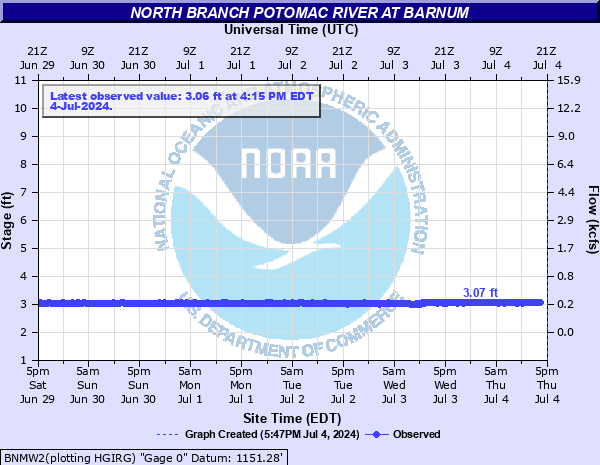
Federal and state agencies maintain river level monitors throughout the Potomac River Basin. The U.S.Geological Survey compiles real-time information from river monitors, in cooperation with the U.S. Army Corps of Engineers and the National Oceanic and Atmospheric Administration (NOAA).
For more USGS data on this site, select this link.
Nearby Potomac River Stream Monitors | |
Upstream | Downstream |
To view a map of Potomac River Monitors, select this link. | |
Suggested Links
Contact Information
U.S. Geological Survey
5522 Research Park Drive
Baltimore MD 21228
443-498-5500
Website