Interactive Maps
Mount Vernon to Anacostia River
Search Potomac Sites
Also Explore
| The Hudson River Guide | The Delaware River Guide |
| The Connecticut River Guide | |
Conococheague Creek
Tributaries
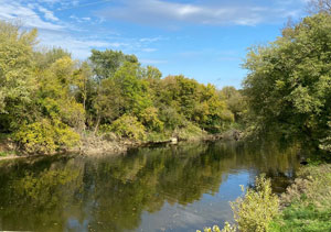
Conococheague Creek runs 80 miles from Pennsylvania to the Potomac near Williamsport, Maryland. The watershed is approximately 566 square miles, mostly in Pennsylvania. The creek meets the Potomac River after flowing under the C&O Canal's Conococheague Aqueduct.
The word "Conococheague" is translated from the Delaware Indian or Unami-Lenapi term meaning "many-turns-river." The Conococheague, or Connogochegue, as it was known at the time, was the northernmost extent of the range along the Potomac within which Congress in the Residence Bill of 1790 authorized the establishment of the Federal District, known as the District of Columbia. By presidential proclamation, George Washington placed the District at the lower end of the range, near the "Eastern Branch", later Anacostia River, which marked the southernmost extent of the Residence Bill's range.
Suggested Links
Contact Information
Maryland Department of Natural Resources
580 Taylor Ave.
Annapolis MD 21401
877-620-8DNR
Website