Interactive Maps
Mount Vernon to Anacostia River
Search Potomac Sites
Also Explore
| The Hudson River Guide | The Delaware River Guide |
| The Connecticut River Guide | |
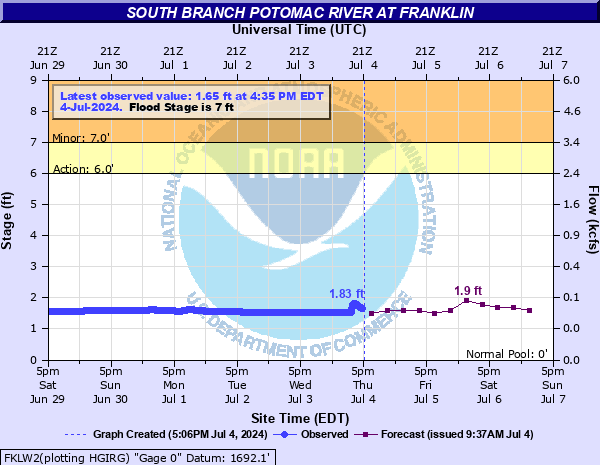
South Branch Potomac at Franklin WV
USGS Streamflow Monitor

The U.S. Geological Survey operates a stream monitoring site on the South Branch Potomac River at Franklin, West Virginia, designated as station 01605500. Located in Pendleton County, this site provides continuous real-time data on river stage and discharge, supporting flood forecasting and water resource planning in the region. It monitors a drainage area of approximately 179 square miles and sits at an elevation of about 1,693 feet above sea level. The station contributes to long-term hydrologic records and is used to assess seasonal flow variations, flood risks, and watershed health in the upper Potomac basin. Its data also inform emergency management and environmental research efforts across eastern West Virginia.
Federal and state agencies maintain river level monitors throughout the Potomac River Basin. The U.S.Geological Survey compiles real-time information from river monitors, in cooperation with the U.S. Army Corps of Engineers.
NOAA has an online chart of flow conditions and forecasts, as shown by the chart below:
For more data on this site, select this link.
![]()
Suggested Links
Contact Information
U.S. Geological Survey
1730 E Parham Rd.
Richmond WV 23228
Website