
Interactive Maps
The Upper Delaware
The Middle Delaware
Easton to Trenton
Trenton to Wilmington
Lower Delaware
Boat Ramps
Bridges and Ferries
River Gages
Search Delaware Sites
Also Explore
| The Potomac River Guide | The Hudson River Guide |
| The Connecticut River Guide | |
Cape Henlopen State Park
Delaware State Park
Situated at the mouth of the Delaware Bay sits Cape Henlopen State Park and its 6 miles of coastline. Cape Henlopen, where the Delaware Bay meets the Atlantic Ocean, shaped the history of this landscape. For millenia, native people lived off the land’s abundant and rich resources and in the late 1600s, William Penn’s family granted the land and allowed citizens to harvest many of the same resources.
The area’s strategic position led to the construction of Fort Miles during World war II with its fire control towers along the Atlantic coast and, which served as a federal defensive site both during and after the war. A diverse collection of habitats makes up the coastal ecosystem of Cape Henlopen State Park. Barrier dune, coastal beaches, and maritime forest are home to many species of plants and animals. Visitors can visit the Seaside Nature Center to participate in an interpretive program or learn about the park’s native plants and animals.
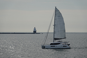
The Harbor of Refuge Lighthouse stands as a sentinel at the mouth of Delaware Bay, just off the coast of Cape Henlopen State Park in Lewes, Delaware. Built in 1926 atop the outer breakwater, this conical cast-iron structure replaced earlier temporary lights that had been battered by storms. Rising 76 feet above the water, it was designed to guide ships into the National Harbor of Refuge, a safe anchorage for vessels navigating between New York and the Chesapeake Bay. The lighthouse features a white flash every 10 seconds and was automated in 1973, though its rugged offshore location still demands regular maintenance. While not accessible by foot, it can be viewed from the northeastern end of Cape Henlopen State Park or visited by boat through seasonal tours offered by the Delaware River & Bay Lighthouse Foundation.
Suggested Links
Contact Information
Delaware Dept. of Natural Resources and Environmental Control
15099 Cape Henlopen Dr.
Lewes DE 19958
Website